
Super high-resolution survey in Greenland
A University expedition has used an exciting new surveying technique to improve understanding of glacial flooding in Greenland.

Dr Duncan Quincey, Dr Jonathan Carrivick and Joseph Mallalieu (all School of Geography) used the emerging technique of ‘structure-from-motion with multi-view stereo’ (SfM-MVS) to analyse bedrock parts of a river channel at an unprecedented resolution.
“Worldwide, glacier margins are retreating, loss from glaciers is increasing and the consequent meltwater often forms temporarily ‘ponded’ in glacier lakes. Many of these lakes are unstable and can drain rapidly producing outburst floods,” explains Dr Carrivick.
“Glacier outburst floods can cause loss of life, displacement of populations and damage to infrastructure, but our understanding of them is limited, due to their suddenness and short-lived nature and also the power of the flow which makes direct measurements extremely difficult. Flows are not easy to understand because they cause rapid landscape change, causing erosion and routing through complex channels. They frequently accelerate and decelerate, with rapid and abrupt changes in energy and capability to erode, transport and deposit sediment. So, new methods of surveying are needed to identify sources of sediment from outburst floods and the changes that take place between events.”
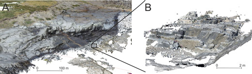
SfM uses novel digital photogrammetric and computer vision methods for simultaneously reconstructing camera pose and 3D feature geometry using multiple, overlapping digital photographs. It produces super high-resolution topographic models to improve flood modelling (A) and also provides baseline data to compare future surveys against, allowing quantification of bedrock erosion and sediment redistribution (B).
“This project collected the imagery using a combined ground-based and airborne approach,” explains Dr Carrivick. “Surveyors walked on the river banks, getting hand-held camera images at each new perspective, producing around 300 images for each site. Additionally, a quadcopter took multiple aerial photographs of the bedrock gorges, and was invaluable for speed of survey and for imaging inaccessible and exceptionally complex areas. The resulting topographic datasets have centimetre-decimetre resolution, which far surpasses any previous elevation models of the site.”
The team is now analysing the multi-scale data with a view to improving models of flood routing and propagation – for hazard analysis via information on time to inundation and hydraulics – and improving understanding of rapid bedrock erosion.The research was funded by the Royal Institute of Chartered Surveyors, administered by the Royal Geographical Society.
Posted in: Research and innovation